New Atmospheric Correction for Slope Stability Radar

 GroundProbe’s Head of Research & Development, Pat Bellett
 GroundProbe’s Co-Founder, Dr Glen Stickley
Precision Atmospherics® sees a significant advancement in controlling atmospheric clutter that is typically associated with interferometric slope monitoring radar.
Atmospherics can make user interpretation and the setting of geotechnical alarms non-intuitive and difficult, especially when trying to avoid unwanted alarms. As the size of open cut mine operations increase, the atmospheric influence gets harder to manage.
In the early 2000’s, the first GroundProbe SSR operated in small pits or across strip mines where a maximum radar range of about 400m was sufficient. Now, the new SSR-Omni covers an imaging range of up to 5.6km. The improvements are significant; however, atmospherics have made meaningful data capture, interpretation, and management increasingly complex for larger open cut mines.
As we have been able to scan faster, more broadly and at longer ranges, the true variability of the atmosphere has been increasingly exposed. The advancements in monitoring capabilities significantly increase the complexity and severity of atmospheric conditions observed through slope monitoring radars.
Precision Atmospherics® shows promising improvement in controlling the inevitable atmospheric clutter associated with interferometric slope monitoring radar.
Atmospheric Phenomena
Atmospheric elements do not behave homogenously, especially over very large areas and long ranges. There is a high degree of uncertainty and unpredictability even in dry desert-like conditions or warm humid climates where typical conditions would be expected to occur.
They are compounded by rapidly changing micro-climates created because of water vapour movements with the wind. Variation comes in the form of spatial character, from bubbles of all sizes, to very thin bands, to horizontal layers—all of which can change rapidly or persist over time.
Unpredictability makes interpretation and setting of geotechnical alarms in the development path for slope stability radar in open-cut mining problematic. The lack of atmospheric consistency makes scanning within a spatially diverse atmosphere more difficult and disrupts the Standard Stable Reference Area (SRA) technique which is typically used to capture, monitor, and manage movement.
Longer ranges and broader scan radar angles have exposed the extent to which atmospheric micro-climates can change in and around open-cut mines, commonly called pits. Primarily it is the amount of water vapour in the atmosphere that determines the radar propagation path variability: the refractivity or dielectric properties of the air are modified by the amount of water and are affected by changes in temperature, pressure and humidity.
Radar Technology
Radars with an ability to scan faster, more broadly and at longer ranges reveal the true variability of the pit’s atmosphere.
Slope Monitoring Radars
All slope monitoring radars rely on the same underlying technique of ‘phase-based interferometry’ which is sensitive to the two-way propagation path length changes introduced by the atmosphere. The interferometry measures the combination of wall deformation and atmospheric effects using a ruler only half a wavelength long. If the movement changes by more than plus or minus a quarter wavelength it is considered ambiguous. Therefore, radars operating at a lower frequency and with a longer wavelength have an advantage because they can tolerate larger changes before ambiguities occur. Atmospheric induced ambiguities require careful consideration when interpreting slope monitoring radar data.
Design Parameters
To achieve longer operational ranges and still be able to image wall movements of a given size with a similar degree of detail, a basic requirement is that the effective imaging resolution should also increase.
There are three key design parameters that drive the spatial resolving power of slope monitoring radars: for 2D radars, the combination of antenna horizontal aperture size and operational frequency determines azimuth or cross-range resolution; and, finally, the transmitted waveform bandwidth determines the resolution in range.
For 3D radars the second dimension is elevation and the third is range. Elevation resolution is determined by antenna vertical aperture size and operational frequency. Stated simply, this means that a bigger antenna, a higher frequency, or both, combined with more bandwidth, translates to better resolution or smaller resolution cells.
The size of an antenna beam footprint scales with range, which is why there is a need for more resolution at longer ranges. How much resolution is required is another interesting question, but it is beyond the scope of this paper.
Stable Reference Area (SRA)
The SRA method has been successfully used for real-time safety-critical monitoring while not missing failures. It detects within days, weeks or months when moving areas reach a rate greater than the noise.
The challenge of atmospheric correction remains – given the increased amount of atmosphere over broader areas and longer distances. High level clutter or noise can be superimposed on the deformation time series data for a selected pixel area that can make information difficult to interpret.
Atmospheric noise can swamp early low velocity movements of ductile materials. Alarm thresholds are routinely set high to avoid false and frequent triggering and a high level of understanding is required in detection.
The new Precision Atmospherics® correction algorithm is a significant geotechnical improvement over the classic stable reference area (SRA) method.
Precision Atmospherics®
The new Precision Atmospherics® process resolves the limitations of the SRA method by using both space and time processes to classify and then appropriately correct areas that are small rapid brittle failures, large slow-moving ductile failures, and non-moving areas.
Severe atmospherics can create interferometric phase ambiguities that contaminate areas of the raw deformation image, which also introduces unwanted steps in the deformation time-series data for the affected areas of wall.
Precision Atmospherics® attempts to resolve these severe events to keep better data continuity and make monitoring more effective over much longer time periods.
To minimise the risk associated with increased complexity in the radar data processing, the traditional SRA data is processed and displayed for each pixel for each scan and can be visualised alongside the Precision Atmospherics® deformation. This makes the two data processing methods complementary.
Trends in the pixel deformation time-series, especially those showing progressive exponential behaviours are more likely to be revealed earlier using Precision Atmospherics®. This simple method of simultaneous comparison demonstrates that the new processing also suppresses the atmospheric clutter to a consistent level across the entire image.
With Precision Atmospherics® the clutter is typically suppressed to about ±1mm depending on the severity of the atmospheric conditions. There is approximately a five-fold improvement in atmospheric noise as seen on pixel deformation time series charts.
Setting alarm thresholds becomes simpler and more closely related to geomechanics rather than atmospherics.
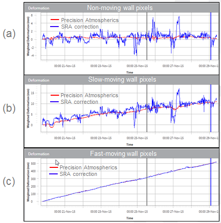
Figure 1 shows examples of the improvement in atmospheric correction for a 2D RAR (SSR-FX), for three different areas moving at different rates.

Figure 1 Deformation time-series charts for three different wall areas scanned by a 2D RAR (SSR-FX) comparing SRA correction (blue) with Precision Atmospherics® (red). Examples show trend agreement and atmospheric clutter suppression with Precision Atmospherics®. The deformation time-series comparison (a) shows pixels selected on a non-moving area of wall; (b) slow-moving area of wall; (c) fast-moving area of wall.
Precision Atmospherics® has considerably relaxed the need for even faster scanning. SSR-FX and SSR-Omni currently acquire data between 20 and 40 seconds and repeat scans every one to two minutes.


