Employing Slope Stability Radar Technology for Effective Geotechnical Risk Management in Civil Applications

 GroundProbe’s Senior Geotechnical Engineer – Americas, Andrei Torres
Landslides are more widespread than any other geological event in the world. In the last 20 years, they have caused 18,000 deaths worldwide.
Up until recently, identifying an instability process with enough time to ensure the safety of human life and amenity has been incredibly challenging, in most of the cases the slopes are not monitored at all and when they are monitored there are significant limitations using traditional methods. This is particularly so in the case of civil applications where traditional monitoring activities have primarily focussed on measuring the movement of the ground surface.
Ground-based slope stability radar technology is proving an effective tool to monitor slopes and help to predict the likelihood of a landslide occurring. The data obtained from the radar can be used not only as a warning system, but to help differentiate the potential impact of different dynamics across a variety of environments, from significant weather events to remediation works.
Slope Failures
Landslides occur in a wide variety of forms and environments. When they occur, they are generally a result of the slope’s geology, rheology and the destabilising forces caused by the environment, weather elements and human activity.
Under these circumstances, slopes are prone to drops in shear resistance posing serious threat to communities and facilities when they rupture. The precursory signs are not always obvious and can result in a lack of advance warning of the need to evacuate the area. The inability to effectively detect precursory ground displacements stem from:
- Limited number of measuring points
- Lack of ancillary data supporting the installation of a monitoring network
- Unawareness about the presence of ongoing instability phenomena
- Difficult site accessibility
- General economic or logistical constraints
Because of this and due to the variability of a slope’s instability processes, it is difficult to characterise its behaviour through traditional geotechnical modelling methods and monitoring tools.
Landslide hazard assessments have typically relied on maps of landslide susceptibility and catalogues of landslide occurrence and corresponding rainfall amounts. The data from these sources does not generally contain a comprehensive enough description of conditions needed to induce landslides, because conventional rainfall thresholds and the associated stability models have considerable uncertainty.
Since 2001, interferometric radar technology has been well accepted in the mining industry as a system to identify and quantify the slope failure hazard. It has been a fundamental requirement to safely sustain production.
Now, this technology has started to find its way to deal with natural hazards and civil applications. The emergence of slope stability radar technologies to monitor slope movement has opened numerous opportunities including being able to potentially identify, quantify and mitigate the risk of geological hazards.
Ground-Based Slope Stability Radars
Ground-based slope stability radars have proved to be a unique tool for surface deformation monitoring. These instruments calculate the deformation-induced phase shift of the back-scattered electromagnetic signal between two acquisitions with no need to install physical instrumentation.
Slope monitoring radars are either Real Aperture Radar (RAR) or Synthetic Aperture Radar (SAR). The fundamental difference is the radar dimensionality which is used to image and spatially map deformation for three-dimensional slope surfaces.
RAR traditionally uses either a fine pencil beam to provide full 3D imaging (3DRAR) or a fine vertically elongated fan beam for 2D imaging (2D-RAR). SAR uses a synthetic (virtual) fine vertically elongated fan beam for 2D imaging (2D-SAR).
Monitoring Information
Along with the displacement data, the slope stability radars also collect other three additional parameters: coherence, range, and amplitude, which are also quite useful to understand the nature of the monitored area and the dynamics of the instability processes.
Displacement – To calculate the displacement of a given area the ground-based radars use interferometry: two subsequent radar signals are compared to calculate the phase difference between the two consecutive acquisitions. If no movement has occurred on the target between scans, the phase angle of the incoming signal stays constant. If movement has occurred between scans, there will be a difference in phase angle which can be converted into displacement.
 |
| Figure 1. Displacement calculation using ground-based radar interferometry. |
Coherence – which is controlled by the reflectivity of the ground and temporal decorrelation between the acquisitions. Decorrelation results from disturbances between two acquisitions. Highly correlated acquisitions show high coherence values whereas de-correlated observations will be expressed by a drop in coherence values depending on the degree of disturbance in the surface.
Range – which is the distance measured from the radar toward the target. It is calculated from the time of flight of the signal, the speed of the light and the time required for radar signal to be transmitted and reflected to radar.
Amplitude – which represents the strength of the signal reflected back to the receiver which is a function of the characteristics of the surfaces such as shape and material.
Case Study: Bogota-Medellin Highway, North Colombia
Geotechnical Risk Scenario
In late 2016, some minor rockfalls and debris flows were observed on the Bogota-Medellin highway in North Colombia. Field inspections revealed some cracks in the upper hill that may be associated with a simple translational mechanism, which has presumably driven by a period of unusual adverse weather conditions. This partially interrupted the heavy traffic between Bogota and
Medellin cities (around 22.000 vehicles/day) and since the slope showed signs of further instability it remained closed during the following days.
 |
| Figure 2. The impacted slope at the Bogota-Medellin highway (K14+000), North Colombia. |
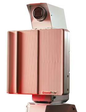
A real aperture Slope Stability Radar was deployed at site on December 28 to verify the stability conditions, determine the size of the potential unstable area, and characterize the displacement processes.
First Results
12 hours after the deployment of the system, the radar imagery revealed the extent of the landslide area, the displacement trend and rates and it was possible to validate the assumptions that were done by field inspection about the failure mechanism.
This occurred by overlaying the 3D-RAR information on a high-resolution camera image which allowed for visual correlation of the information. The advantage of this integration was in facilitating the detection of the features in the scan areas throughout the cumulated 2D imagery.
Zone A showed no evidence of any change either on its deformation trend or in its deformation rates because of the rain events during the period. Zone B showed acceleration processes that could be directly correlated with some of the rain events.
The colour scale in the radar displacement image shows displacements from −30 to +30 mm during the first 12 hours. Positive values (red to yellow) show displacement along the LOS towards the observer, negative values (light blue to violet) away from the observer, and green values represent zero displacement.
The coherence image represents the degree of decorrelation between the acquisitions. Decorrelation results from strong movements within a resolution cell, for example, due to debris, vegetation cover or differential displacements.
 |
| Figure 3. 12 hours after the ground-based radar system was used the radar imagery revealed the extent of the landslide area and made it possible to validate what was identified by field inspection about the reasons for slope failure. |
Radar Monitoring during the Recovery Works
The ground-based slope stability radar technique was used to monitor to provide opportune information to make sound decisions during the recovery works.
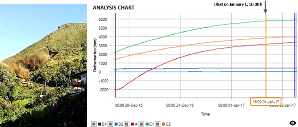
On January 1, the local authorities try to induce a landslide by performing a blast. It was expected this blast to lead to a collapse of the unstable material and the ground-based radar information allowed to track the response of the slide in real-time.
 |
| Figure 4. Displacement analysis for the blast performed on 1 January 2017. |
During the following months (December 2016 to August 2017) the recovery works focused on reconfiguring the slope to reduce the overall angle and to conform a set of benches. A total of 18 collapses and falls of ground were reported.
Many of these events were correlated with precipitation events and the remedial works that were undertaken in the area (the ground-based slope stability radar collects weather information that allowed to verify this in real time) and most of them were timely and effectively predicted by analysing the monitoring data.
During the period June-August 2017 the deformation rates decreased, this evidence allowed to validate the efficacy of the remediation plan and the monitoring campaign was finished.
 |
| Figure 5. Inverse velocity plot for slide prediction. Location of a predicted landslide. |
 |
| Figure 6. Remediation works progress in March 2017 |
Ground-based slope stability radar is proving to be effective in civil applications to help understand the different dynamics and key environmental triggering factors. It’s future as an effective tool in civil engineering applications is highly promising, with the data it can provide able to assist in mitigating risk and reducing the impact of rockfalls and landslides on people, property, and critical infrastructure.
The use of accurate and real-time displacement calculation and other radar parameters identified different dynamics in a challenging area which had active debris, dense vegetation cover, precipitation events and remediation works and provided information to make sound decisions during the recovery works.


