A New Atmospheric Correction Algorithm for Ground-Based Radars

 GroundProbe’s Group Geotechnical Sales Specialist, Albert Cabrejo

GroundProbe’s Head of Research and Development, Pat Bellett
 GroundProbe’s Co-Founder, Dr Glen Stickley
For the last five years, GroundProbe has been developing a new atmospheric correction technique which has been tested at mine sites around the world. While open pits have been monitored for over a decade using ground-based interferometric radar technology, the transition of this technology from small pits to large pits has brought with it the challenges associated with complex atmospheric conditions.
A new algorithm – Precision Atmospherics® (PA) – has been designed to overcome some of the limitations of current atmospheric correction methods, while guaranteeing the same reliability of existent techniques on the market. This new technique allows users to set tighter alarms during real-time monitoring, providing better risk management at open-pit mine sites and ultimately improving the quality of data overall.
For geotechnical engineers, the algorithm presents the real possibility to configure alarms that trigger on rock mass displacement, as opposed to calibrating them to match the local atmospheric conditions to minimise unwanted alarms. The algorithm improves the radars capability to track small displacements in small and large mines, necessary for long-term data analysis.
Technical Background
Applied Interferometry Technique
Radar interferometry is a remote sensing technique applied in space-borne and ground-based technologies for open pit mines. It aims to estimate movement on targets with submillimetre accuracy, for example, the movement in open pit walls and natural slopes. High accuracy is required to detect even the smallest displacements, ensuring there is appropriate warning before slope failure to allow for safe evacuation of personnel and equipment.
The interferometry technique estimates the difference in the phase angle of two consecutive returning signals from a slope. If no movement has occurred on the target between scans, the phase angle of the incoming signal stays constant. If movement has occurred between scans, there will be a difference in phase angle which can be converted into displacement.

Figure 1: Simplified Representation of Interferometry Technique
Data Acquisition
A simplified view of the whole radar process, from radar signal generation to the final display of displacement images, is summarised in the diagram below. The generation of the right radar signals, beam forming, beam focussing, storing, mathematical processing and interferometry are generally processes that are well under control, leaving only the atmospheric management as the critical step to address in the data acquisition process. The main application of the PA algorithm is on the last stages of this process – atmospheric characterisation and compensation – which occurs before the generation of imagery.

Figure 2: Simplified Process of Radar Data Acquisition
Atmospheric Behaviour and Correction Techniques
Atmosphere is not a constant, and the larger the air volume involved in a radar measurement, the larger the influence of atmospheric variability. This variability is caused by changes in temperature, pressure and humidity which can impact the overall density of water vapour in the air. This changes the speed at which the signal travels through the air, and consequently, the phase angle that is measured by the radar and the displacement attributed to it.
There have been several atmospheric correction methods developed, including weather stations (WS), stable reference areas (SRA), dynamic stable reference areas (DSRA), and persistent scatters (PS). While each method has its merits, the significant limitations of these methods have led to the need to develop this new algorithm.
A New Precision Atmospherics® Algorithm
For almost five years, GroundProbe scientists have been investigating new techniques to address the issues observed when deploying existing atmospheric correction techniques in complex environments. The result is the new PA algorithm, which preserves the safety and reliability of the SRA technique while addressing spatial atmospherics issues. In addition, a key development focus was to not suppress displacement, especially from areas moving fast to failure, as observed in real cases with the PS technique.
Case Studies
Case Study 1 – Layered Atmospheric ‘Chilean Camanchaca’
This site is a mine in Chile where the ‘Camanchaca’ effect takes place – a phenomenon by which dense fog rapidly appears and covers, for instance, the upper half of the pit for hours at a time. Figure 3 shows two displacement plots, one with the DSRA method and the other with the PA algorithm, and the difference in noise level is significant. In Figure 4, the difference between the algorithms and an ideal linear trend is shown. It is assumed that the perfect linear trend represented the real behaviour of the wall. While the DSRA displacement delivers errors of up to 10mm, the PA algorithm shows errors within 2mm.

Figure 3: Dynamic Stable Reference Areas Versus Precision Atmospherics®

Figure 4: Errors of Dynamic Stable Reference Areas and Precision Atmospherics® Against an Ideal Linear Trend
From the histogram in Figure 5, it can be concluded that the noise distribution is better and smaller with PA – with a central value of zero and a narrow spread, compared to DSRA that spreads from -5mm to 1.6mm.
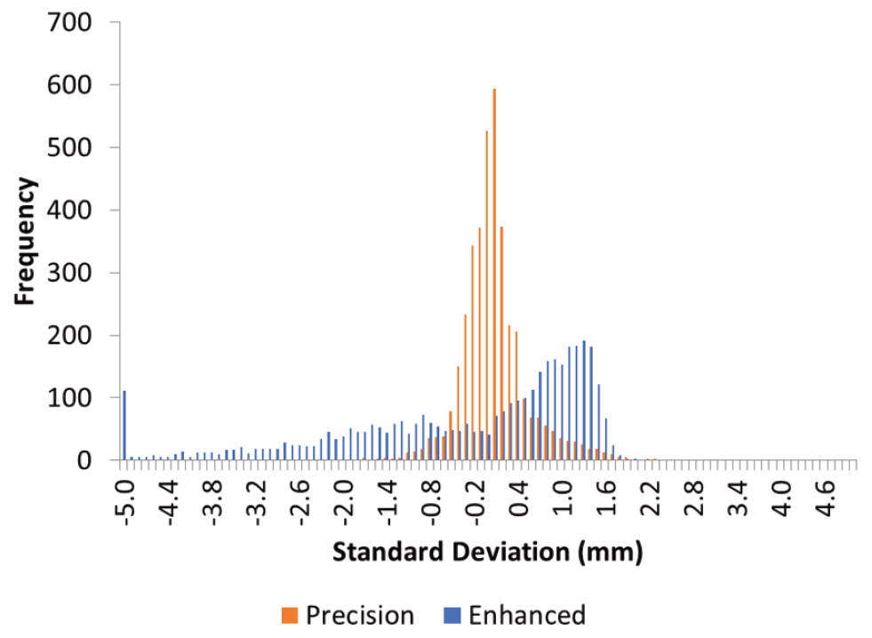
Figure 5: Histogram of Errors
Case Study 2 – The Collahausi Mine: High Altitude, Extreme Atmospherics and ‘Viento Blanco’
For the last three years, Collahuasi and GroundProbe have collaborated in the testing and improvement of the PA algorithm. The Collahuasi mine in northern Chile is over 4,300m above sea level and experiences very strong atmospheric conditions, particularly the ‘viento blanco’ effect (wind with snowflakes in the air). The mine is very large – over 2.8km in range and 1km deep, with dumps outside the pit and at longer ranges – and faces significant atmospheric contamination.
Figure 6 shows the difference in the displacement readings on an area of the mine that is moving at a very slow rate. While the trend with DSRA corrected displacement (blue plot) is difficult to interpret, the PA plot (orange) clearly shows 2mm of displacement accumulated during the monitoring period. Figure 7 shows the histograms of noise on total accumulated displacement, with the DSRA showing larger errors spread across the histogram compared to the PA displacement that delivers errors with submillimetre accuracy. The spatial extent of this slow-moving area was also clearly visible in the PA displacement images, while difficult to see in SRA displacement images.
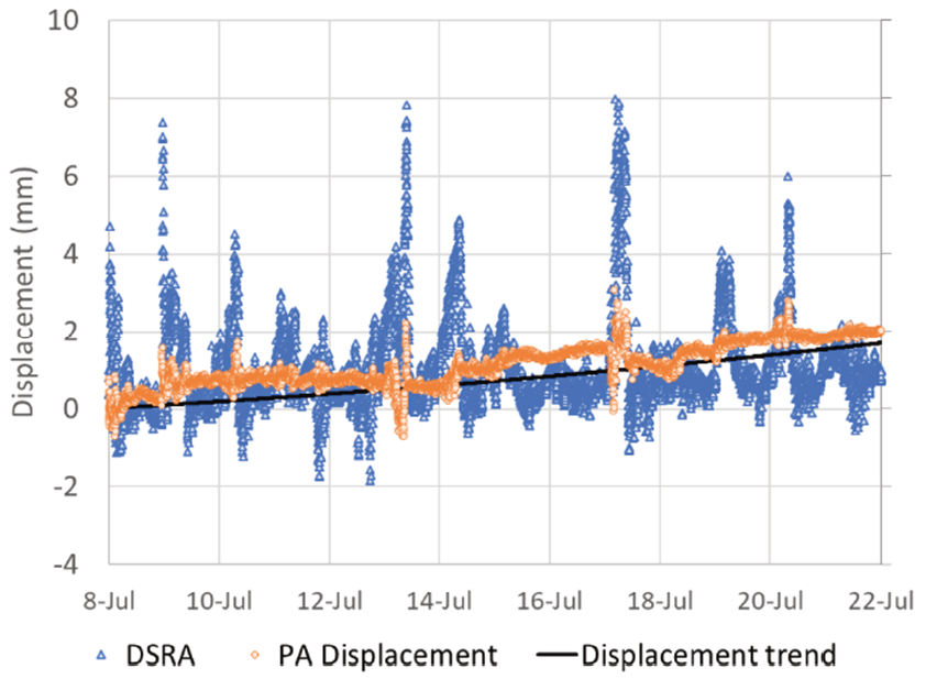
Figure 6: Dynamic Stable Reference Areas Versus Precision Atmospherics® on a Slow-Moving Area
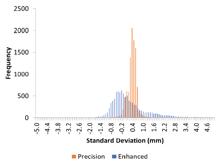
Figure 7: Slow Movement Histogram
Case Study 3 – Super Pit
The PA algorithm was also tested in a very large open pit where several radar manufacturers have failed to deliver good data quality over long periods in ‘broad-area background mode’. Figures 8 and 9 show an area of the mine 1,400m from the radar. In Figure 9, a small deforming area was detected using the PA algorithm. In Figure 8, the same area is shown using DSRA correction, but the saturation of red colour caused by atmospherics prevents the user from identifying the true deformations occurring on the slope. In this case, PA allowed the user to find areas of concern that would not have been detected with the classic DSRA method.
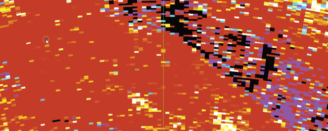
Figure 8: Dynamic Stable Reference Areas Displacement Image
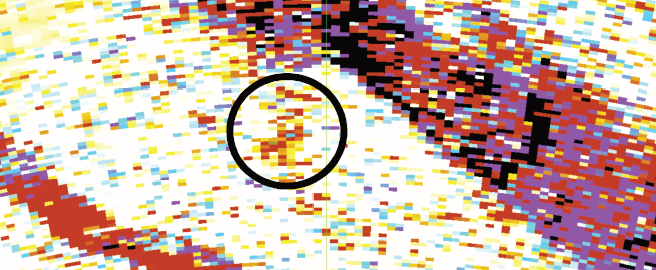
Figure 9: Precision Atmospherics® Displacement Image
A Significant Step for Radar Technology in Open-Pit Mines
The PA algorithm represents significant progress for radar technology for open-pit mines, showing improvements in many test conditions – across small, medium and large mines, in dry and rainy environments, in periods of snow and dust, and at varying altitudes. By addressing the limitations of existing radar technologies, the PA algorithm has improved the data quality produced by ground-based radars, allowing users to set tighter alarms during real-time monitoring, and delivering improvements to safety, productivity, communication and ease of use.
Read More
This article is a summary of the paper Risk management and alarming based on a new atmospheric correction algorithm from ground-based radars by A Cabrejo, P Bellett, G Stickley, R Silva, Y Gunaris and J Perez. The paper was presented at the 2020 International Symposium on Slope Stability in Open Pit Mining and Civil Engineering on May 12, 2020.


