Providing the support needed to ‘mine-to-plan without harming anyone’

 GroundProbe Chief Commercial Officer & VP Americas, Ben Moke
A little over two decades ago, a group of PhD students and their professor from the University of Queensland set out to make mining safer. By developing the slope stability radar (SSR), they, and many other innovative thinkers who have since joined them, have succeeded in achieving their safety mission.
Safety has always been at the heart of GroundProbe – it’s part of our DNA. However, in an era defined by technological leaps and sustainability imperatives, our focus has shifted to supporting the mining industry to become safer, more productive, and more sustainable.
In a meeting earlier in 2023, our leadership team sat down with one of the industry’s most experienced and respected geotechnical practitioners, Martyn Robotham, as part of our 5-year strategy development. During this meeting, Martyn so eloquently put it to us – the simple question that a Mine Manager asks an onsite geotechnical engineer is: ‘How can you help us mine-to-plan without harming anyone?’
How do we help to deliver on this objective?
From developing precision-measuring devices and AI-driven software to our geotechnical support services and the breadth of technologies and partnerships we deliver to our customers, GroundProbe’s solutions are all focused on enabling the mine to mine-to-plan without harming anyone.
Solutions empowering continuous mining operations without compromising safety
GroundProbe is the only provider of ground-based radars that delivers both Real Aperture Radars (RAR) and Synthetic Aperture Radars (SAR). Both technologies solve different problems for the mine. Through the ability to deploy the right technology to match the problem or task at hand increases the decision confidence of the Geotechnical Engineer.
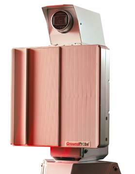
At the core of our suite of solutions is our 3D Real Aperture Radar (3D-RAR) SSR-XT – still the most proven and trusted tactical monitoring radar in the global market even after two decades. The ‘XT’ provides independent measurements across the surface of a wall in a raster pattern, providing pure data results that are uncontaminated from high-energy targets such as mining machinery.
Our 2D Real Aperture Radars (2D-RAR), SSR-FX, and SSR-OMNI provide fast, 360-degree, broad area coverage of the mine, providing valuable strategic and long-term monitoring insights into the mine. The recent release of Precision Atmospherics® is a game changer for managing contamination from the atmosphere without compromising the integrity of the data collected in a scan area. To quote one of our customers who employs all radar technologies from all providers:
“Precision Atmospherics did not only improve the maps, but it also improved the source data represented on a pixel basis by the Deformation vs. Time plots. Consequently, the images were better. This means that Precision Atmospherics reduced the amount of noise on a scan-by-scan basis, which opened the door to us for considering tighter alarms that in turn reverted into improved TARP systems and overall safety management in our operations.”
Partnering with best-in-class technology providers is integral to us being able to provide other types of sensor data that our customers can translate into valuable information. Our innovation pipeline and partner selection process mean we select the best partners to collaborate with. Such partners include 3VGeomatics (InSAR), Navstar (GNSS and Data Visualization software), Trimble (Total Stations), Elexon (sub-surface monitoring sensors), and Geobotica (LiDAR, short-range radar, AI hardware and software, and robotics).
Bringing all of this together is our team of over 170 geotechnical engineers delivering geotechnical support services (GSS).
GSS Monitoring Services is the global ground-based radar monitoring and safety standards bedrock. This team provides real-time, 24/7 remote (or onsite) monitoring and reporting of GroundProbe and partner sensors. This service provides mine operations with peace of mind that when any slope movement becomes a problem, operations will be pre-warned to act in time.
Safety and productivity are not enough; sustainability is imperative
Environmental stewardship is the cornerstone of responsible mining. GroundProbe’s Doppler radar system, the RGR-Velox, provides real-time reactive monitoring of geo-hazards and plays a pivotal role in monitoring critical tailings dam infrastructure. Combined with data from other multiple sensors and geotechnical support services, customers can secure a social license to operate, meet community expectations, effectively rehabilitate and construct safer tailings storage facilities while prioritizing safety standards and emergency response capabilities.
As market leaders, we are famous for making mining safer. Our vision sets a firm focus on empowering safer and more sustainable operations and in doing so, enabling our customers to ‘mine- to-plan without harming anyone.’
– Ben
At GroundProbe we are a global team of innovators renowned for pushing boundaries and revolutionising the industry with cutting-edge technologies, pioneering thinking and innovative digital solutions that play a crucial role in safeguarding human lives and assets.


